
サービス内容
地球観測衛星が観測する時系列的なSAR画像をジオメトリック・ラジオメトリック的に高い精度で処理し、地盤沈下や隆起・森林減少・災害監視・土地利用変化・変化抽出などの解析を、高い精度で行うソフトウェア(Sigma-SAR)の開発や販売を行います。
また、それらを用いて、環境の変化を高い精度で定量的に取り出す解析を受託します。
We develop and provide the Sigma-SAR software, which processes time-series SAR imagery acquired by Earth observation satellites with high geometric and radiometric accuracy.
The software enables advanced analyses such as ground subsidence and uplift, deforestation, disaster monitoring, land-use change, and change detection.
In addition, we offer contract-based analytical services that quantitatively and accurately extract environmental changes using these datasets.
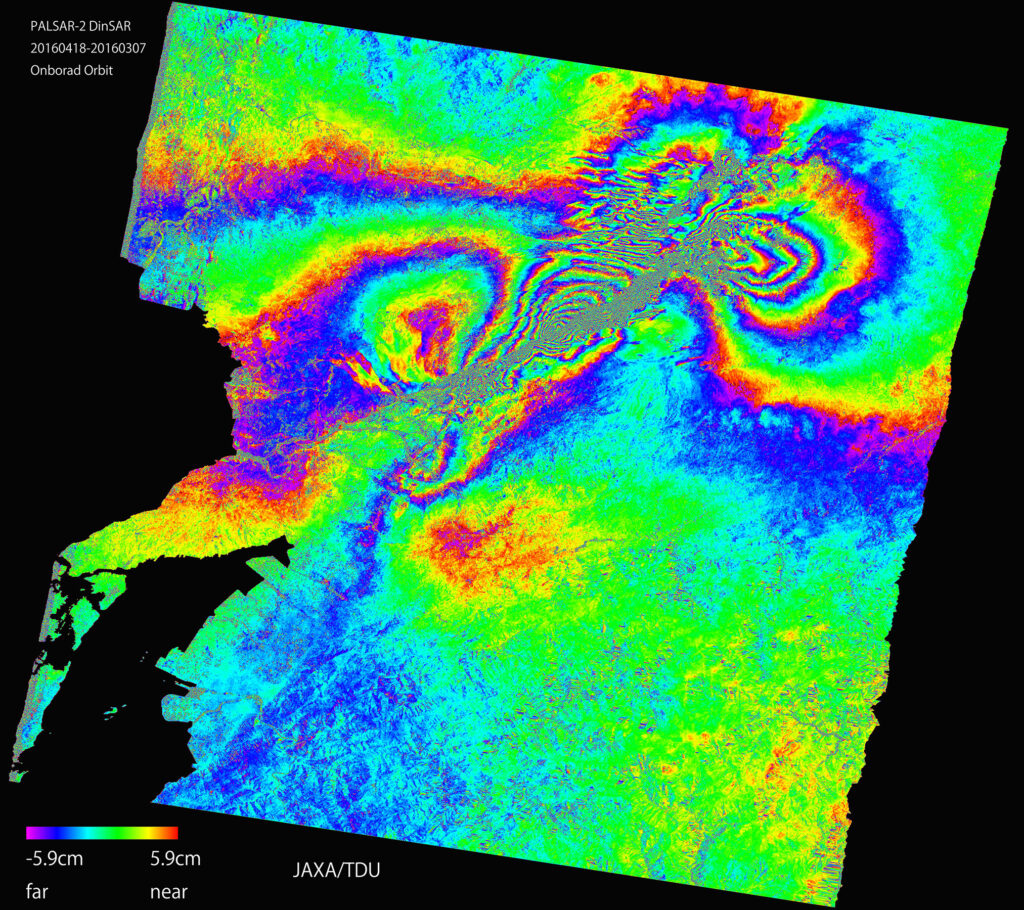
解析内容
時系列インターフェロメトリ処理・変化抽出処理・
ポラリメトリ処理・校正・検証
対象とするセンサ群と入力データ
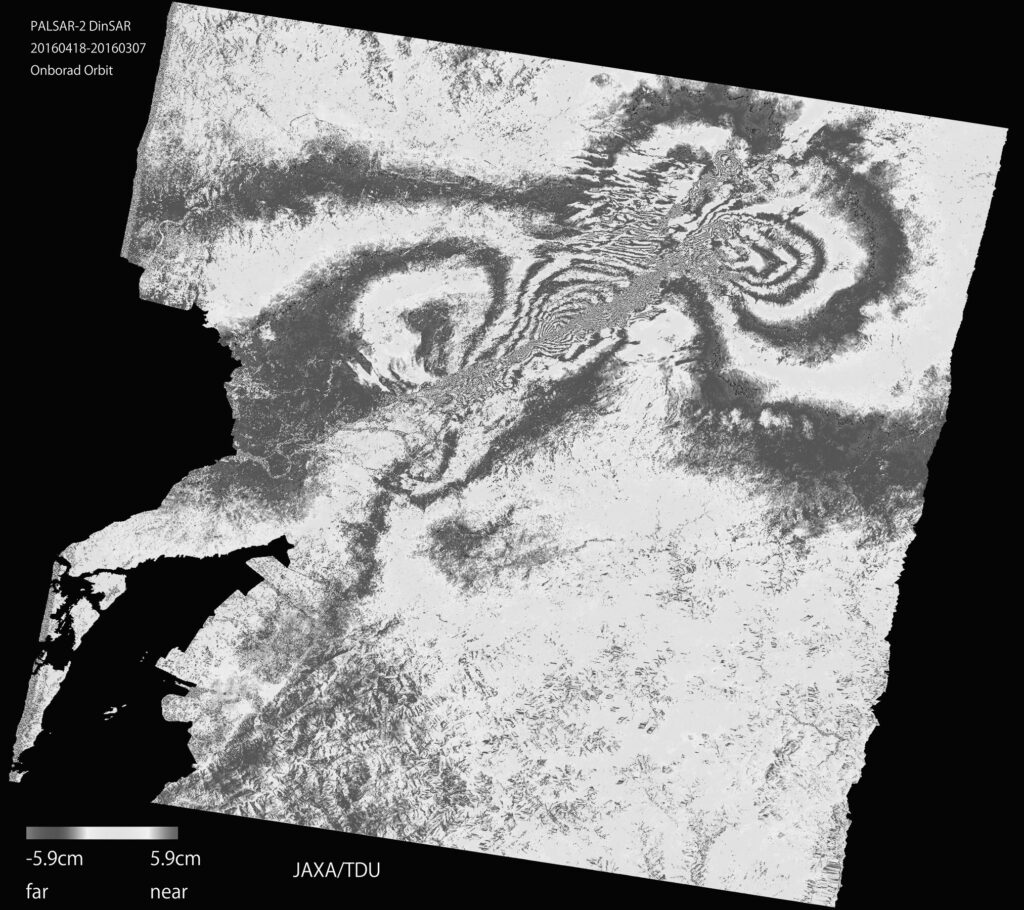
Analysis content
Time series interferometry processing, change extraction processing, polarimetry processing, calibration, and verification
Target sensor group and input data
対象とするセンサ群と入力データ
ALOS/ALOS2/JERS-1, ERS-1, TSX, TDX, CSK, Radarsat-1/2, Sentinel-1
(振幅, Asnaro2, iceye, Saocom, strix, qps )
ほぼ全ての衛星データ,一部の航空機SARデータ
(Pulse radarやFMCW radar)にも対応
Target sensor group and input data
ALOS/ALOS2/JERS-1, ERS-1, TSX, TDX, CSK, Radarsat-1/2, Sentinel-1
(amp, Asnaro2, iceye, Saocom, strix, qps )
almost all satellite data, some aircraft SAR data
( Also compatible with Pulse radar and FMCW radar)
Sigma-SAR概要
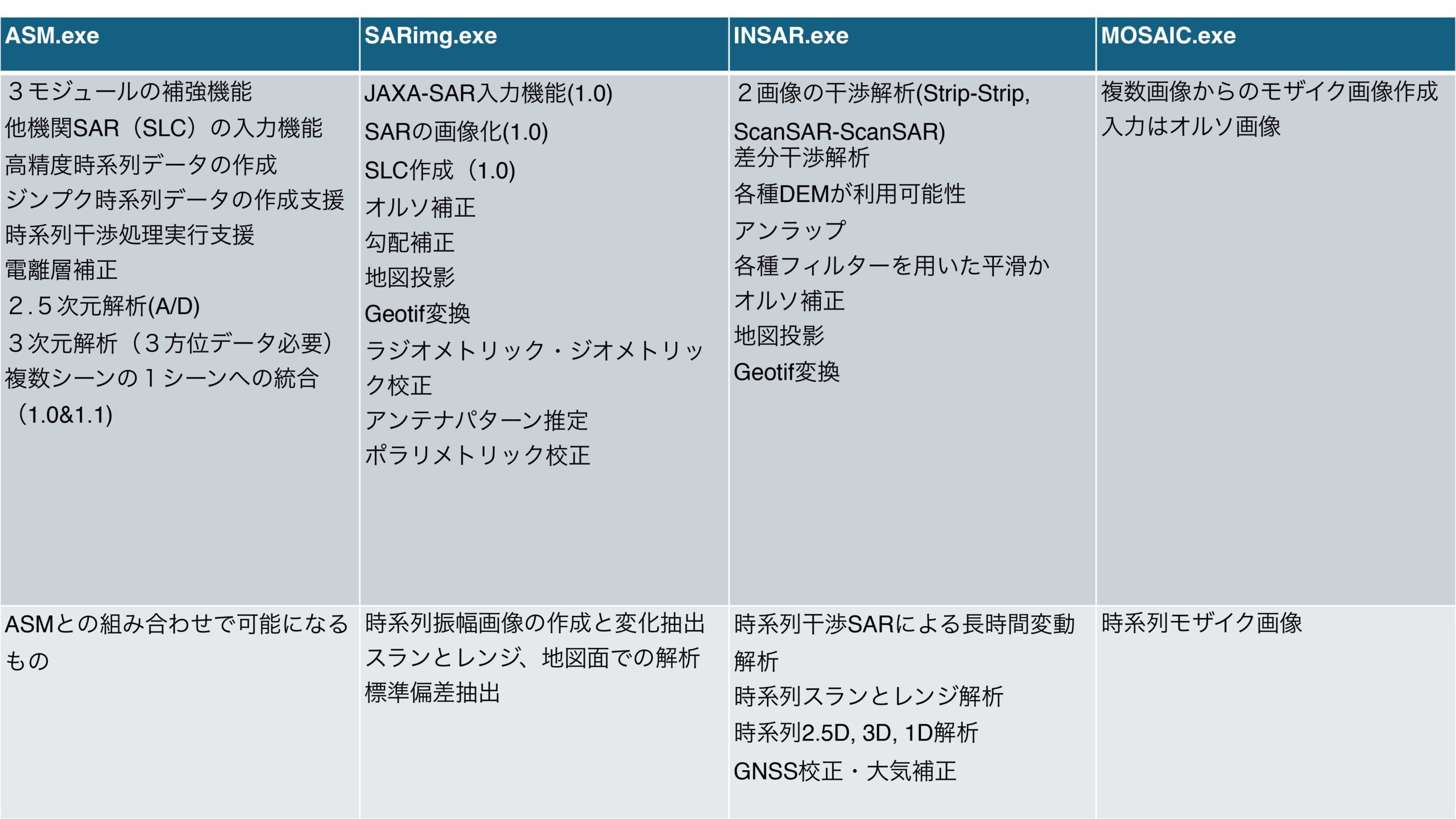
4種類の実行モージュールで構成されます。
1) SARimg.exeはSARの画像化や地図投影、ポラリメトリック解析などを行います。
2) INSAR.exeは干渉処理を行います。
3) MOSAIC.exeはモザイク処理を行います。
4) ASM.exe(Advanced SAR module)は各種SARデータの入力や高精度な時系列解析を支援し、1)、2)と組み合わせて利用されます。
5) OSはLinuxです。
6) 動作はオンプレミスとawsです。また、tellusでの運用が2025年12月からです。
機能の詳細は以下の表をご覧ください。
Sigma-SAR overview
Consists of four types of execution modules.
1) SARimg.exe – Performs SAR imaging, map projection, polarimetric analysis, and related functions.
2)INSAR.exe – Executes interferometric SAR (InSAR) processing.
3) MOSAIC.exe – Handles SAR image mosaicking.
4) ASM.exe (Advanced SAR Module) – Supports the ingestion of various SAR datasets and enables highly accurate time-series analysis. It is designed to be used in combination with 1) and 2).
5) Operating System – Linux
6) Deployment Options – On-premise, AWS, and Tellus (planned for December 2025)
See the table below for feature details.

入力データ
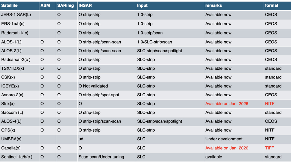
 標準データ(主にSLC、一部raw(L1.0)データ)を入力します。
 衛星ごとの取り扱い可能なデータは以下の表を参照してください。
Input Data
The software accepts standard SAR data (primarily SLC, with partial support for raw Level 1.0 data).
Please refer to the table below for the list of supported datasets for each satellite.
ライセンス・サポート / Licensing & Support
ライセンス形態
Sigma-SARは、大学・研究機関・企業・官公庁向けにライセンスを提供しています。
利用目的や研究内容、サポート内容に応じて最適なライセンスをご提案いたします。
License Types 『Academic-lite』
Sigma-SAR is available for universities, research institutes, commercial companies, and government organizations.
We provide flexible licensing according to your application, project scale, and support requirements.
教育・研究・評価用途向けライセンスです。
教育・研究・評価用途
1解析あたり最大10シーン
年間ライセンス
メールサポート・アップデートを含む
Designed for education, research, and software evaluation.
Education, research, and evaluation
Up to 10 scenes per analysis
Annual license
Includes software updates and e-mail support
Academic
大学・研究機関向けライセンスです。
シーン数制限なし
年間ライセンス
技術サポートを含む
Designed for universities and research institutes.
Unlimited number of scenes
Annual license
Includes technical support
Commercial
企業・官公庁向けライセンスです。
商用利用
プロジェクト規模に応じたライセンス
技術サポート・カスタマイズ対応
Designed for commercial companies and government organizations.
Commercial use
Flexible licensing according to project requirements
Technical support and customization available
技術サービス / Technical Services
ライセンス提供に加え、以下の技術サービスも提供しています。
SAR画像化
干渉SAR解析
時系列解析
放射・幾何学的校正
アルゴリズム開発
技術コンサルティング
技術講習会(オンライン・現地)
お問い合わせ
In addition to software licensing, Sigma-SAR provides technical services including
SAR Image Generation
InSAR Processing
Time-series Analysis
Radiometric & Geometric Calibration
Algorithm Development
Technical Consulting
On-site and Online Training
Contact
ライセンス、価格、技術サポートについては、お気軽にお問い合わせください。
Please feel free to contact us regarding licensing, pricing, technical support, or customized solutions.